
Class 9 · Social ScienceNCERT 2026 Revised Syllabus
Chapter 1: Oceans and Life (0908CH01)
IN-TEXT QUESTIONS AND ACTIVITIES — Chapter 1 (Textbook pp. 3–18) — 11 questions with step-by-step answers.
Jump to:
IN-TEXT QUESTIONS AND ACTIVITIES — Chapter 1 (Textbook pp. 3–18)(11 questions)
p. 3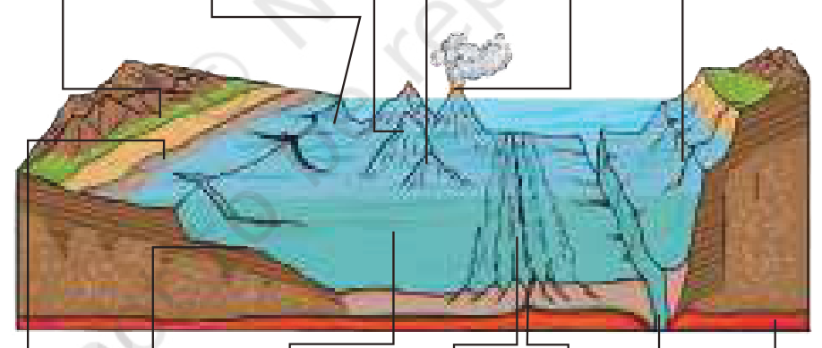
Hard
Looking at Fig. 1.2, answer the following questions.
- a.How do you think these oceanic features would have been formed?
- b.Which part of the ocean floor appears deep and shallow?
- c.How do you think these underwater features would have an effect on marine life and ocean movements?
Ans.
1. How the features form: Continental shelves and slopes are the submerged edges of continents. Mid-ocean ridges form where tectonic plates move apart and magma rises and cools. Trenches form at subduction zones where one plate sinks beneath another. Seamounts are commonly volcanic; wave action may flatten their summits to form guyots. Abyssal plains become smooth through the accumulation of fine sediments.
2. Deep and shallow areas: Continental shelves are relatively shallow. Continental slopes descend to deeper water; abyssal plains are very deep and broad, while trenches are the deepest features. Ridges and seamounts rise above the surrounding seabed.
3. Effects: Shelves receive sunlight and nutrients and support productive fisheries. Ridges, seamounts and trenches provide specialised habitats. Relief can redirect currents, influence mixing and affect the location of nutrients and marine organisms.
p. 4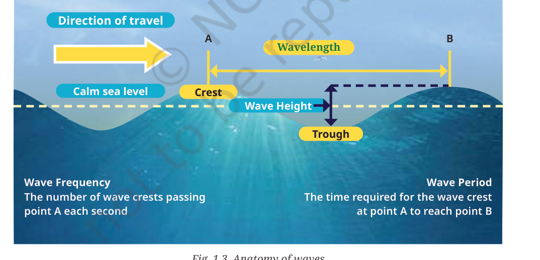
Hard
Observe Fig. 1.3 and Fig. 1.4. Identify a wave’s crest and trough, and describe the sequence of erosional landforms shown, including the original headland.
- a.What are the crests and troughs in a wave?
- b.How do wave actions create the erosional landforms shown in Fig. 1.4?
- c.What is the original headland?
Ans.
In Fig. 1.3, the crest is the highest part of a wave and the trough is the lowest part between two crests. In Fig. 1.4, waves repeatedly attack weaknesses in a rocky headland. Cracks may widen into sea caves; continued erosion can cut through a headland to form an arch. When the arch roof collapses, an isolated sea stack remains. Further erosion and weathering may reduce the stack to a low stump. A headland is a piece of land that projects out into the sea. Beaches are depositional landforms, not part of this erosional sequence.
p. 5
Find the names of some famous sea beaches in India and locate them on a map of India.
- a.Find names of famous sea beaches in India.
- b.Locate and label the selected beaches on a map of India.
Ans.
On an outline map of India, mark and label a selection of well-known beaches. Suitable examples are: Marina Beach—Chennai, Tamil Nadu; Puri Beach—Odisha; Kovalam—Kerala; Calangute or Baga—Goa; Juhu—Mumbai, Maharashtra; Radhanagar Beach—Swaraj Dweep, Andaman and Nicobar Islands; and Digha—West Bengal. Add a title, north arrow and a simple legend. The list is illustrative; any correctly located Indian sea beach is acceptable.
p. 5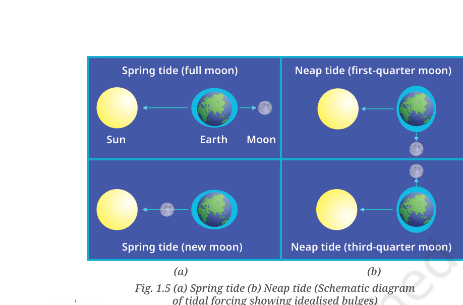
Observe Fig. 1.5 and describe the change in water level during high and low tides.
- a.Observe Fig. 1.5.
- b.Describe how the water level changes during high tide.
- c.Describe how the water level changes during low tide.
Ans.
The diagram shows tidal water bulging on opposite sides of the Earth. At high tide, the sea reaches a higher level and advances farther over the coast. At low tide, the water level falls and the shoreline retreats, exposing parts of the seabed. The regular change is mainly caused by the gravitational pull of the Moon and, to a lesser extent, the Sun, together with the Earth–Moon system’s motion.
p. 7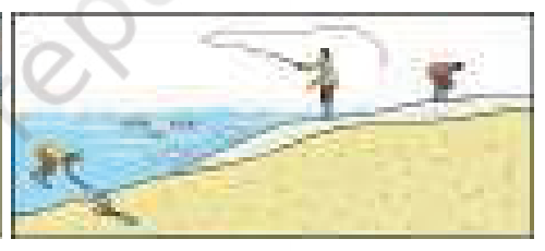
Observe Fig. 1.7. How do high and low tides influence fishing activities?
- a.Observe Fig. 1.7.
- b.Explain how high tides influence fishing activities.
- c.Explain how low tides influence fishing activities.
Ans.
During high tide, rising water allows many fish to move closer to the shore in search of food and shelter. Fishers can use this movement and their knowledge of local tidal timings to plan fishing activities and may obtain a better catch. Tides also change the depth and accessibility of coastal waters, so fishers need to consider tidal conditions for safety. The figure’s main point is that high tides can bring fish nearer to the shore.
p. 8
Observe the map of warm and cold ocean currents. Do these currents affect the temperature of nearby coastal regions?
- a.Observe the map of warm and cold ocean currents.
- b.Explain whether these currents affect the temperature of nearby coastal regions.
Ans.
Warm currents transport water from lower latitudes and can make nearby coastal areas milder and warmer. The Gulf Stream, for example, helps keep parts of north-western Europe relatively mild. Cold currents carry water from higher latitudes and cool nearby coasts; the Labrador Current contributes to colder conditions and sea ice along parts of eastern Canada. Currents also influence humidity, fog, rainfall and marine productivity, although local climate is affected by several factors.
p. 8
Observe Fig. 1.9 and note the ocean currents along the coastline of India. What is the nature of these currents?
- a.Observe Fig. 1.9.
- b.Identify the ocean currents shown along the coastline of India.
- c.Describe the nature or direction of these currents.
Ans.
The surface-current pattern around India changes with the monsoon. During the south-west monsoon, strong winds drive currents in a different direction from those during the north-east monsoon; therefore, the circulation in the Arabian Sea and Bay of Bengal shows a seasonal reversal. Currents also vary with the coastline, temperature, salinity and the wider Indian Ocean circulation. For the map activity, trace the arrows shown in Fig. 1.9 and label the currents as warm or cold only where the map or reliable atlas identifies them.
p. 9–10
The people of Simeulue were partly protected during the 2004 tsunami by local folklore. Find out whether similar traditional stories or practices related to natural disasters exist in your culture, and explain how traditional knowledge can help keep communities safe.
- a.Find out whether communities in India or elsewhere have traditions or stories that warn people about tsunamis or other coastal hazards.
- b.Describe the tradition and explain how it can help people respond to danger.
Ans.
Model response: In many coastal communities, elders pass down stories about unusual natural signs and the need to move away from the shore when the sea suddenly withdraws or the ground shakes strongly. Such knowledge can alert people before official warnings reach them. It should complement, not replace, scientific alerts and evacuation instructions. Families should learn safe routes, practise evacuation and share reliable information with neighbours. Replace this example with a story or practice actually reported by elders in your community.
p. 14
If you receive a tsunami or cyclone alert on your phone, what five steps should your family take to stay safe?
- a.State five practical steps your family should take after receiving a tsunami or cyclone alert on a phone.
Ans.
1. Read the alert carefully and follow instructions from the district administration and disaster-management authorities.
2. Move immediately to a designated cyclone shelter or to higher ground and inland areas for a tsunami; do not go to the beach to watch the waves.
3. Carry an emergency kit containing drinking water, essential medicines, a torch, a charged phone, basic food and important documents in a waterproof pouch.
4. Help children, older persons and people with disabilities, and keep family members informed through a planned contact method.
5. Stay away from floodwater, damaged wires and the coast; return home only after authorities issue an official all-clear.
p. 16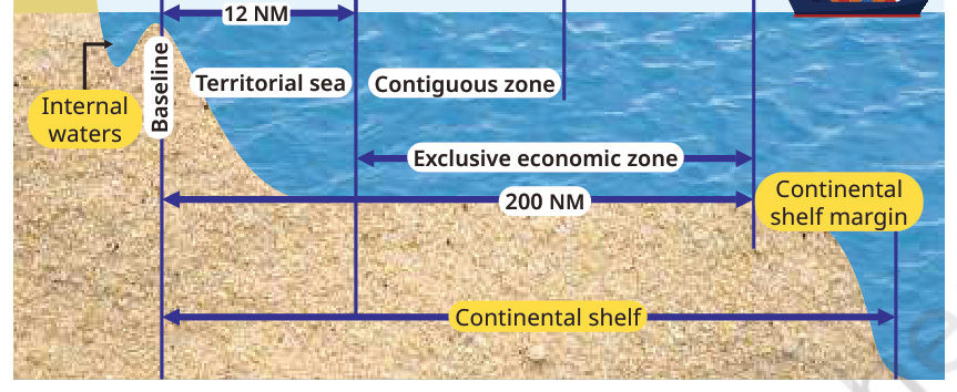
Observe Fig. 1.20 and note the extent of India’s territorial sea in nautical miles.
- a.Observe Fig. 1.20.
- b.Identify the extent of India’s territorial sea shown in nautical miles.
Ans.
The territorial sea extends 12 nautical miles from the legally defined baseline. Within this zone, India exercises sovereignty over the water, seabed, subsoil and airspace, subject to international law, including the right of innocent passage for foreign ships. Do not confuse it with the contiguous zone, which extends up to 24 nautical miles from the baseline, or the Exclusive Economic Zone, which extends up to 200 nautical miles.
p. 18
Find examples of countries that have disagreements over territorial sea waters or maritime areas.
- a.Give examples of countries that have disagreements over territorial sea waters or other maritime areas.
- b.Briefly identify the disputed area or issue and explain why maritime boundaries matter.
Ans.
Examples commonly discussed in geography are the overlapping maritime claims involving China and the Philippines in parts of the South China Sea, and disagreements between Greece and Türkiye concerning parts of the Aegean and eastern Mediterranean. Such disputes may concern islands, maritime boundaries, fishing grounds, seabed resources or navigation. Countries use diplomacy, bilateral agreements, arbitration and international law, including the United Nations Convention on the Law of the Sea (UNCLOS), to resolve disputes peacefully. The exact status of a dispute should be checked from a current, reliable source before a class presentation.