
Class 9 · Social ScienceNCERT 2026 Revised Syllabus
Chapter 2: Life on Earth (0908CH02)
IN-TEXT QUESTIONS AND ACTIVITIES — Chapter 2 (Textbook pp. 22–42) — 21 questions with step-by-step answers.
Jump to:
IN-TEXT QUESTIONS AND ACTIVITIES — Chapter 2 (Textbook pp. 22–42)(21 questions)
p. 22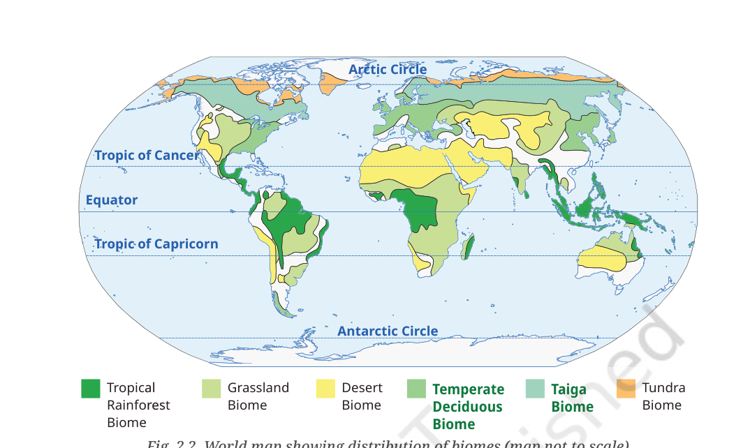
Hard
Study the world map of biomes (Fig. 2.2) and answer the following.
- a.Which type of biome is found in smaller, separate regions, and why?
- b.Which continent has the least number of biomes? What could be the reason for this?
- c.Why are there areas that do not have any specific biomes?
Ans.
1. Small, separate regions: The temperate deciduous biome is shown in separated belts, mainly in eastern North America, Europe and East Asia. Its distribution depends on moderate temperatures and seasonal rainfall, and much of its former area has been converted to agriculture and settlements.
2. Least variety: Antarctica has the least variety of the mapped terrestrial biomes because much of the continent is covered by permanent ice and has extremely harsh conditions. If the question is restricted to inhabited continents, Australia also shows a relatively limited range, with large arid areas.
3. Areas without a specific biome: Permanent ice, very high mountains, transitional zones between biomes and heavily modified landscapes may not fit neatly into one category. The map is simplified and does not show every local ecosystem.
p. 24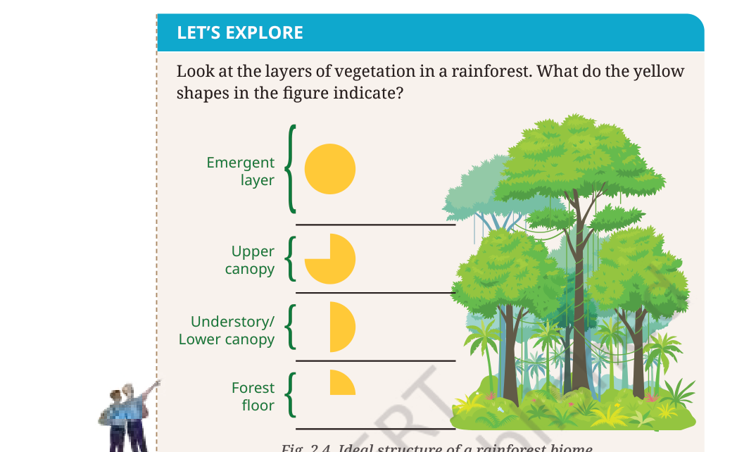
Look at the layers of vegetation in a rainforest. What do the yellow shapes in Fig. 2.4 indicate?
- a.Look at the layers of vegetation in the rainforest shown in Fig. 2.4.
- b.Explain what the yellow shapes indicate.
Ans.
The emergent layer receives the greatest amount of direct sunlight. The upper canopy receives strong sunlight but is partly shaded by taller trees. Much less sunlight reaches the understory, and very little reaches the forest floor because the dense canopy blocks it. The yellow shapes illustrate this decreasing availability of sunlight at lower levels.
p. 25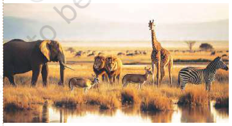
Observe Fig. 2.5 and identify which of the pictured animals are found in the grasslands of India.
- a.Observe Fig. 2.5.
- b.Identify which of the pictured animals are found in the grasslands of India.
Ans.
Among the animals shown, elephants and lions have wild populations in India, although the Indian lion is mainly associated with the Gir landscape and surrounding dry habitats rather than all grasslands. Giraffes and zebras are African animals and are not native wild species of India. Indian grasslands and open scrub also support blackbuck, chinkara, nilgai, Indian wolf, foxes and the Great Indian bustard. The exact species vary with region and habitat.
p. 26
What activities do people in desert regions undertake to sustain their households and livelihoods, and how do they manage water scarcity?
- a.Describe activities through which people in desert regions sustain their households and livelihoods.
- b.Explain how people manage limited water in desert environments.
Ans.
People in desert regions may rear camels, sheep, goats and other livestock; grow drought-resistant crops where water permits; make handicrafts and textiles; trade; work in mining; or provide tourism services. To manage scarce water, communities use tanks, johads, stepwells, rooftop rainwater harvesting, check dams, traditional channels and carefully managed wells. Drip irrigation, drought-resistant crops, wastewater reuse and protection of local water bodies also help. The mix of activities varies by region.
p. 26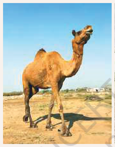
Compare the Rajasthan camel with the Nubra Valley camel. Why does the Nubra Valley camel have a different fur density?
- a.Compare the camel of Rajasthan with the camel of the Nubra Valley.
- b.Explain why the Nubra Valley camel has a different fur density.
Ans.
The Rajasthan camel is generally a one-humped dromedary with long legs and a relatively short coat, adaptations suited to hot desert conditions. The Nubra Valley camel is a two-humped Bactrian camel with a dense, woolly coat that provides insulation against the severe cold of the high-altitude cold desert. Its thick coat is shed partly in warmer months. The difference in fur density is therefore an adaptation to temperature, not simply to sand or dryness.
p. 27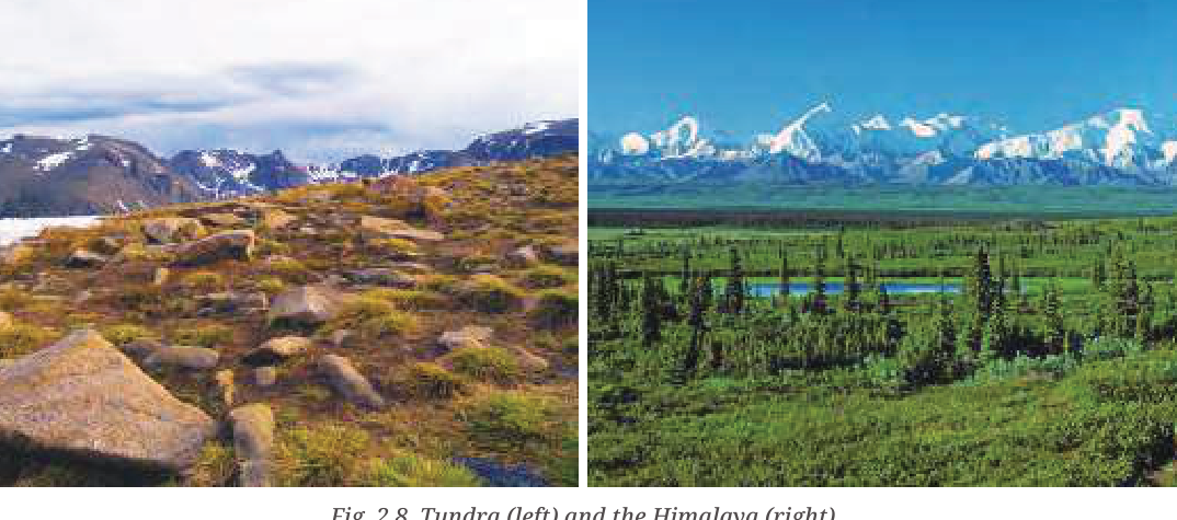
Compare vegetation and animals in the polar tundra and the Himalaya. Why are they different, and which species are found only in the Himalaya?
- a.Compare vegetation in the polar tundra and the Himalaya.
- b.Compare the animals found in these regions.
- c.Explain the environmental reasons for the differences.
- d.Give examples of species found in each region.
Ans.
Polar tundra experiences extremely low temperatures, permafrost, strong winds and a short growing season, so vegetation is mainly mosses, lichens, grasses and small shrubs. The Himalaya has a wide range of altitudes, slopes and local climates. Its lower and middle slopes support broad-leaved and coniferous forests, while higher areas have alpine meadows and sparse vegetation. Himalayan wildlife includes the snow leopard, red panda, Himalayan monal, musk deer, Himalayan tahr and yak. These species are adapted to mountain habitats; not all are strictly endemic only to the Himalaya, so a precise “found only” list should be based on the species distribution map or a reliable biodiversity source.
p. 28
Observe your local environment and complete the table with examples of plants, insects, animals and non-living things, showing how they interact with humans.
- a.Observe your local environment.
- b.Complete the table with examples of plants, insects, animals and non-living things.
- c.Explain briefly how the living and non-living components interact.
Ans.
Model observation table (replace these examples with what you actually observe):
The conclusion should explain that people depend on the local environment and must avoid pollution, habitat destruction and waste.
| Component | Examples observed | Interaction with humans |
|---|---|---|
| Trees/vegetation/plants | Neem, peepal, grass, kitchen-garden plants | Give shade, oxygen, food, medicine and habitat; people water or prune them |
| Insects | Bees, butterflies, ants | Bees and butterflies pollinate plants; ants recycle organic matter, though some may be pests |
| Animals | Squirrels, sparrows, cows, dogs | Provide companionship, food or services; some feed on insects or disperse seeds |
| Non-living things | Soil, water, rocks, air, buildings | Support life, farming, drinking, construction and daily activities |
p. 29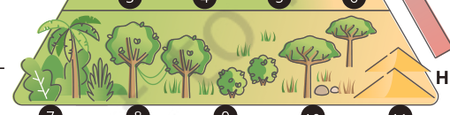
Mark Andaman and Nicobar Islands, Keralam, Ladakh, Chhattisgarh, Odisha, Meghalaya and Lakshadweep at suitable positions on the biome diagram. Where would you place your home?
- a.Mark Andaman and Nicobar Islands, Keralam, Ladakh, Chhattisgarh, Odisha, Meghalaya and Lakshadweep at suitable positions on the map.
- b.Use the map to connect each location with its characteristic biome or ecosystem, as shown in the textbook.
Ans.
The diagram is a simplified climate–biome model, so placements are approximate rather than exact state-wide classifications. Ladakh belongs near the cold, dry or alpine end. Meghalaya and the Andaman and Nicobar Islands are generally warm and wet, supporting tropical forests. Much of Chhattisgarh and Odisha has tropical seasonal or deciduous vegetation, although local climates vary. Keralam is tropical and receives heavy monsoon rainfall, supporting wet evergreen and moist deciduous forests. Lakshadweep has a warm tropical maritime environment. Place your home according to the local temperature and rainfall pattern of your town or village, not simply the state name.
p. 29
The biome pyramid has no arrow on its third side. If an arrow were drawn, which direction should it point and why?
- a.Identify the missing arrow on the third side of the biome pyramid.
- b.State the direction in which it should point.
- c.Explain the direction using the relationship among producers, consumers and energy flow.
Ans.
Energy enters the ecosystem through producers such as plants and algae, which capture sunlight. Herbivores feed on producers, and carnivores feed on other consumers. Therefore, the direction of energy transfer is upward from the base towards higher trophic levels. The amount of available energy, biomass and often the number of organisms generally decreases at higher levels because energy is lost as heat during life processes.
p. 31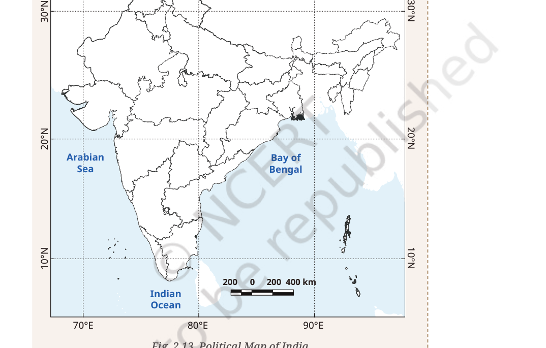
Mark the six biodiversity regions listed in Fig. 2.13 on the map of India and collect information about their features.
- a.Mark the six biodiversity regions listed in Fig. 2.13 on a map of India.
- b.Collect information about the characteristic features of each region.
Ans.
1. Namdapha National Park: Arunachal Pradesh; Eastern Himalayan forests with exceptional biodiversity.
2. Rann of Kutch: Gujarat; seasonal salt marsh and desert wetlands supporting flamingos and other wildlife.
3. Gahirmatha Beach: Odisha; important nesting site for Olive Ridley sea turtles.
4. Gulf of Mannar: Tamil Nadu; marine biosphere reserve with coral reefs, seagrass and coastal biodiversity.
5. Pachmarhi: Madhya Pradesh; Satpura hill forests and diverse central Indian species.
6. Achanakmar–Amarkantak: Chhattisgarh–Madhya Pradesh region; forested highlands and important watershed habitats.
Use the map scale, label each place clearly and add a legend.
p. 32
Is there an ecotourism site in your State or Union Territory? Collect information and discuss it with your friends.
- a.Identify an ecotourism site in your State or Union Territory.
- b.Collect information about its ecosystem, attractions and conservation practices.
- c.Discuss how tourism can support local people without damaging the environment.
Ans.
Model response: Thenmala in Keralam is described in the textbook as India’s first planned ecotourism destination. It combines recreation and environmental education with forest conservation and local employment, including guides and service providers from nearby communities. For a local answer, choose a recognised forest or wildlife destination in your State/UT, then describe its ecosystem, visitor activities, conservation rules, community participation and benefits to local livelihoods. Do not claim that a site is sustainable merely because it attracts tourists; explain the safeguards it uses.
p. 33
What should a tourist’s behaviour be while visiting a tourist site? What should one be mindful of?
- a.Describe how tourists should behave while visiting a tourist site.
- b.State what visitors should be mindful of to protect local people, wildlife and the environment.
Ans.
Visitors should carry reusable items, put waste in the proper bins, avoid single-use plastic, stay on marked paths, and never feed, chase or disturb wildlife. They should not pluck plants, damage monuments, make excessive noise or light fires in prohibited areas. Visitors must respect local customs, seek permission before photographing people, conserve water and energy, use local services responsibly and follow the instructions of guides and forest authorities.
p. 33
Why are sacred groves special, and how do they help conserve biodiversity?
- a.Explain why sacred groves are special.
- b.Describe how sacred groves help conserve biodiversity.
Ans.
Sacred groves are forest patches protected through religious, cultural or customary rules. Because tree cutting and hunting may be restricted, they can preserve old native vegetation, rare medicinal plants, birds, insects and other wildlife in landscapes where natural habitats have otherwise declined. Their vegetation protects soil, supports pollinators and may help maintain springs and groundwater. Sacred groves also preserve traditional ecological knowledge and show how cultural practices can support conservation.
p. 34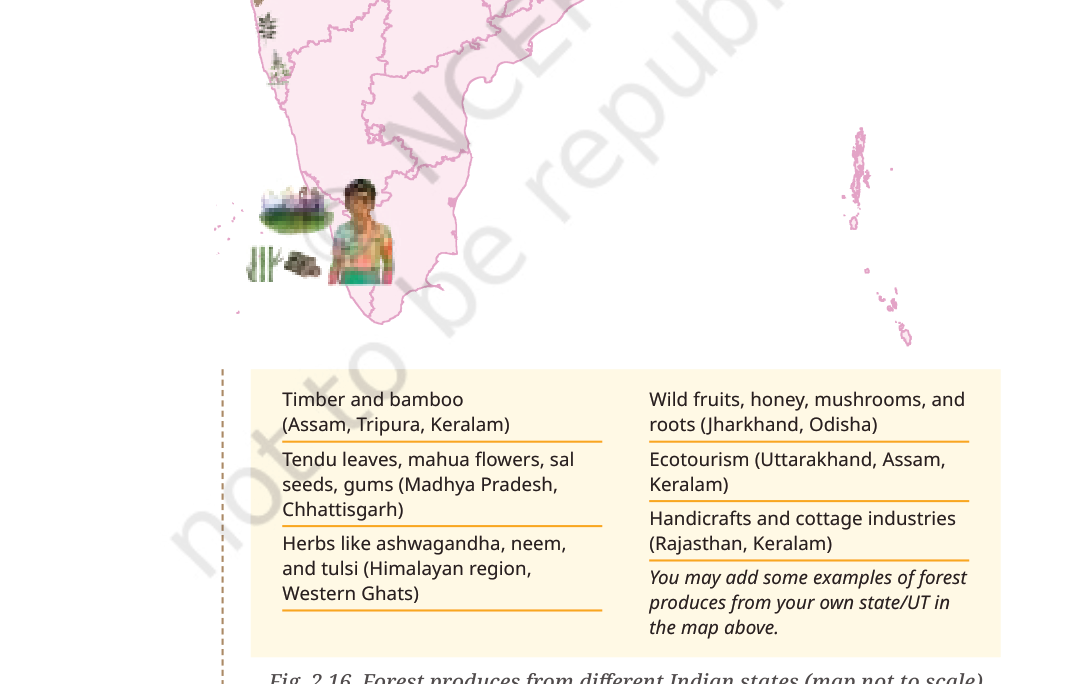
Add examples of forest produce from your own State or Union Territory to the map in Fig. 2.16.
- a.Add examples of forest produce from your own State or Union Territory to the map in Fig. 2.16.
- b.Identify the location and the forest product associated with it.
Ans.
Model examples to place only where they are locally found: bamboo and cane in Assam, Tripura and parts of the North-East; tendu leaves, mahua flowers, sal seeds and lac in parts of central and eastern India; honey, wild fruits, mushrooms and medicinal plants in forested regions; and herbs such as neem, tulsi and ashwagandha in suitable areas. Add the product name beside the State/UT and verify it with a local forest department, market or community source.
p. 36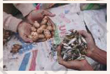
Identify and classify the items for sale in Fig. 2.18. Also list food and medicinal varieties available in your local market.
- a.Identify the items for sale in Fig. 2.18.
- b.Classify the items into suitable categories.
- c.List food products and medicinal varieties available in your local market.
Ans.
The photographs show traditional forest-based livelihoods, including people making or selling woven bamboo products, food items and gathered forest produce. A useful classification is: (i) food products—honey, wild fruits, nuts, mushrooms, roots, tubers and local grains; (ii) medicinal products—herbs, leaves, roots and plant-based preparations; and (iii) craft and household products—bamboo baskets, mats and other handmade goods. A local-market list may include turmeric, ginger, tulsi, neem, honey, amla, tamarind and seasonal fruits. Record only products actually found in your market.
p. 38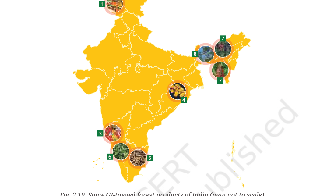
Explain how GI tagging of forest products connects geography, cultural traditions, local governance and the rural economy. Name GI-tagged forest products from your State or Union Territory.
- a.Explain how GI tagging of forest products connects geography with cultural traditions.
- b.Explain the role of local governance.
- c.Explain possible benefits for the rural economy and producers.
Ans.
A Geographical Indication identifies goods whose quality, reputation or other characteristics are essentially linked to a particular geographical origin. Soil, climate, forest vegetation and local biodiversity can influence the product. Traditional communities preserve the skills and methods used to produce it; producer groups and public institutions help maintain standards and protect the name. Recognition can improve marketing, create value for local producers and encourage conservation of the landscape and knowledge on which the product depends.
Examples shown in the textbook include Ramban Sulai Honey (Jammu and Kashmir), Tezpur Litchi (Assam), Channapatna Toys made from Wrightia tinctoria wood (Karnataka), Kandhamal Haldi (Odisha), Erode Turmeric (Tamil Nadu), Nilgiri Tea, Tripura Queen Pineapple and Khasi Mandarin (Meghalaya). Select the item relevant to your own State/UT and confirm the current GI register when preparing a formal project.
p. 38–39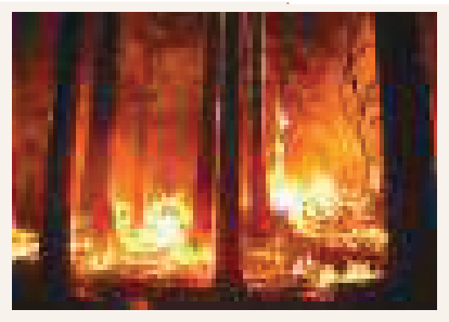
Explore forest-fire locations on the School Bhuvan–NCERT Geoportal. Identify the patterns you observe and explain how the location, season, forest type, nearby settlements and local conditions may help in understanding fire risk.
- a.What patterns can be observed in the locations and seasonal distribution of forest fires?
- b.What information about forest type, nearby roads or settlements, weather and vegetation should be recorded?
- c.Why can a map show where fires occurred but not, by itself, prove the cause of a particular fire?
Ans.
Use the School Bhuvan–NCERT Geoportal to identify clusters of reported fires. For each location, record the State/UT, date or season, forest type, proximity to roads or settlements and any other information shown by the map. Compare the pattern with rainfall, temperature, drought, dry vegetation and human activities such as unattended campfires, discarded smoking materials, agricultural burning or deliberate land clearing. A map shows where fires were reported; it does not, by itself, establish why a particular fire started. Check official Forest Department or Forest Survey of India information before assigning a cause. Conclude with prevention measures such as community awareness, early reporting, fire lines where appropriate, careful management of dry vegetation, trained response teams and protection of vulnerable settlements.
p. 38–39
Think About It — The textbook notes that a substantial share of India’s forest cover is prone to forest fires and that climate change and human activities contribute to the risk. Explain why forest fires are a serious concern, identify factors that increase their likelihood, and suggest preventive measures.
- a.What damage can forest fires cause to forests, wildlife, soil, homes and the livelihoods of forest-dependent communities?
- b.How can climatic conditions and human activities increase the likelihood or spread of forest fires?
- c.What practical measures can communities and authorities take before, during and after a forest fire?
Ans.
Forest fires are serious because they can destroy vegetation and wildlife habitats, reduce biodiversity, damage soil, release smoke and harmful gases, threaten homes and roads, and interrupt the livelihoods of forest-dependent communities. The textbook cites a Forest Survey of India estimate that about 36 per cent of the country’s forest cover is prone to fires, with nearly 4 per cent described as extremely prone; these are the figures cited in the textbook, not a substitute for checking the latest official assessment.Factors increasing risk: prolonged dry spells, high temperatures, low humidity, strong winds and dry leaf litter can allow a fire to start or spread. Climate change can intensify some fire-weather conditions. Human causes include unattended campfires, burning of waste or farm residues, discarded smoking materials, deliberate fires and careless use of fire near forests.Prevention and response: communities should avoid lighting fires in or near forests, extinguish permitted fires completely, report smoke or flames immediately, follow official warnings and keep roads and access routes clear for response teams. Forest authorities can monitor high-risk areas, maintain suitable fire lines, train local response teams, conduct awareness programmes and use early-detection systems. People should move away from danger and follow evacuation instructions rather than attempting to fight a large fire themselves.
p. 39
How are the benefits of the Pradhan Mantri Ujjwala Yojana (PMUY) affecting women’s health?
- a.Explain how the benefits of the Pradhan Mantri Ujjwala Yojana (PMUY) can affect women’s health.
- b.Mention the role of cleaner cooking fuel and the importance of safe, sustained access and use.
Ans.
The PMUY supports eligible households in obtaining LPG connections. Replacing or reducing the use of wood, dung and crop residues for cooking can reduce exposure to smoke and fine particles inside the home. This can lower the risk of respiratory irritation and other health problems, improve kitchen conditions and reduce the time and physical effort often spent collecting fuelwood. The benefits depend on whether households can afford and regularly obtain LPG refills; access to a connection alone does not guarantee complete transition to clean cooking.
p. 39
Which wild animals have you seen in or near your residential area? Identify why they enter human settlements.
- a.Identify wild animals you have seen in or near your residential area.
- b.Suggest reasons why these animals may enter human settlements.
- c.Mention a safe, non-harmful response that reduces conflict.
Ans.
Model response: Depending on the region, residents may see monkeys, deer, wild boar, elephants, snakes or birds near settlements. Such encounters can increase when forests are cleared or fragmented, roads and buildings interrupt animal corridors, crops and garbage provide food, or drought reduces water and natural food. Seasonal movement and population growth may also bring animals closer to people. Communities should secure waste and crops, protect corridors, avoid feeding wildlife and contact trained forest officials rather than harming animals.
p. 42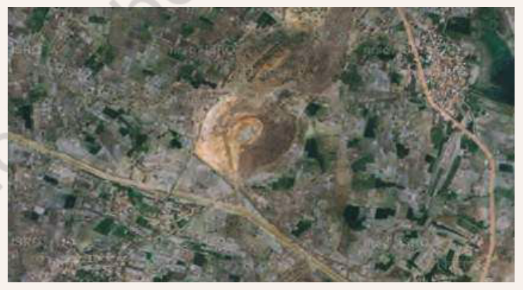
Study Fig. 2.24. Identify water tanks and mark the agricultural fields irrigated by them.
- a.Study Fig. 2.24.
- b.Identify the water tanks shown.
- c.Mark the agricultural fields irrigated by those tanks.
Ans.
This is a map-reading activity based on the School Bhuvan image. First identify the tanks or reservoirs as distinct water bodies. Next look for channels, field boundaries and cultivated plots connected to or lying below the tanks. Shade or outline the likely irrigated fields and add a legend distinguishing tanks, channels and agricultural land. The precise fields must be taken from the displayed image and local map layers; do not invent tank names or boundaries when they are not legible.